
Growing apprehension surrounds Hurricane Hilary’s potential to unleash extensive flooding rainfall upon the southwestern United States and portions of California. This unusual trajectory is expected to occur from Sunday into early next week, marking a unique occurrence that has prompted the issuance of the first-ever tropical storm watch for California.
Hilary has the capacity to deposit a volume of rain that surpasses an entire year’s worth in certain areas of California, Nevada, and Arizona. Consequently, specific parts of California face an exceptionally rare and high risk of experiencing excessive rainfall. This Level 4 out of 4 threat level, issued for Southern California, is an unprecedented event.
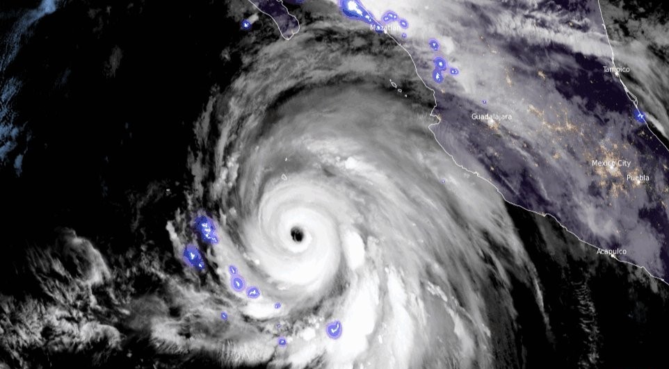
As of Friday afternoon, Hurricane Hilary stood as a potent Category 4 hurricane, located approximately 325 miles south of Cabo San Lucas, Mexico. The National Hurricane Center reported sustained winds of 130 mph with even stronger gusts. The storm underwent a remarkable rapid intensification, escalating from a tropical storm to a Category 4 hurricane within a mere 24 hours from Thursday to Friday.
The forecast indicates that Hilary will retain its Category 4 status as it approaches Mexico’s Baja California peninsula through Saturday. Consequently, authorities have initiated hurricane and tropical storm watches and warnings for Baja California, encompassing the Los Angeles area and extending northward to Point Mugu in Ventura County, as well as northwest Mexico.


The storm’s path in the United States carries varying possibilities for the most potent winds as it progresses northward over the next couple of days. Slight deviations in the hurricane’s course could lead to alterations in the predictions for the most intense rainfall and wind.
Hilary is moving at a faster pace than anticipated, implying that both Mexico and California should anticipate impacts earlier than initially projected. The storm’s core is now predicted to approach the central portion of Baja California on Saturday night, subsequently advancing inland over southern California by Sunday night. It’s noteworthy that areas will experience strong winds and heavy rainfall well before the hurricane’s center arrives.
Although Hilary is more likely to make landfall in Mexico before crossing into California, there remains a possibility of it hitting California as a tropical storm. If this occurs, it will be the first tropical storm to make landfall in California in almost 84 years, according to data from the National Oceanic and Atmospheric Administration.
The issuance of the inaugural tropical storm watch for parts of Southern California took place on Friday morning, extending from the California/Mexico border to the Orange County/Los Angeles County demarcation.
“The potential for significant wind impacts continues to rise for northern parts of the Baja California Peninsula and the Southwestern United States, especially in mountainous regions,” warned the hurricane center on Thursday night.
Anticipated to considerably weaken before reaching Southern California and the Southwest, Hilary still poses a threat of exacerbating heavy rainfall and elevating flood risks. The onset of substantial rainfall is projected to affect the Southwest from Saturday onward, with the most intense downpours anticipated for Sunday and Monday.
The extraordinary risk associated with excessive rainfall cannot be underestimated. Although high risks are declared on fewer than 4% of days annually on average, they contribute to 83% of flood-related damage and 39% of flood-related fatalities, as indicated by research from the Weather Prediction Center.
Southern parts of California and Nevada could potentially receive 3 to 5 inches of rain, with isolated areas possibly accumulating up to 10 inches. Central areas of these states, along with western Arizona and southwest Utah, are anticipated to experience rainfall ranging from 1 to 3 inches.
Thanks to Hilary, there is a possibility of “multiple years’ worth of precipitation” falling in some of California’s driest regions, according to Daniel Swain, a climate scientist at the University of California, Los Angeles.
One of these areas is Death Valley, renowned as the hottest place on Earth. This desert region typically receives around 2 inches of rain per year. Moisture from Hilary could lead to a remarkable scenario where 1 to 2 years’ worth of rainfall is dumped in a single day, potentially transforming the landscape. Similarly, Las Vegas could witness 2 to 4 inches of rain, a significant departure from its annual average of 3.75 inches.
The continuous rain might saturate the ground and inundate waterways, further exacerbating the risk of flooding. Due to the potential for flooding from the storm, Mojave National Preserve, situated on the California-Nevada border, has been closed until further notice.
Southern California residents, spanning from San Diego to Los Angeles, have been advised of the potential for floods over the weekend, prompting flood watches. The National Weather Service in Los Angeles has also cautioned about the possibility of high surf, rip currents, and coastal flooding.
Not to be overshadowed by the East Pacific, the Atlantic region is preparing for a noteworthy surge in tropical activity in the upcoming days. Four distinct areas of concern span the entire basin, ranging from west of the Cabo Verde Islands to the Gulf of Mexico. Of immediate interest to the United States is a region in the exceptionally warm Gulf of Mexico, where atmospheric conditions are conducive to supporting tropical development in the following week. A low-pressure area might gradually organize in this basin, gaining strength and acquiring tropical characteristics over the western Gulf by midweek.
In the tropical Atlantic, three separate areas warrant attention. A cluster of disorganized showers and thunderstorms west of the Cabo Verde Islands could potentially evolve into a tropical depression over the weekend, potentially intensifying into a tropical storm. Another region of disturbed weather just west of this area could also develop into a tropical depression by early next week. Lastly, an area near the Lesser Antilles holds a low probability of attaining tropical characteristics.
(Source: CNN)